
Mani-utenam
Mani-utenam, which means “Mary’s village”, is a territory acquired by the federal government in 1948, and designated as an Indian Reserve the following year. When it was founded, it was made up primarily of families associated with the Moisie River, or "Mishta shipu". Other families who were settled in Uashat, moved there in the 1950s. Mani-utenam is 16 km east of Sept-Îles.
Phonetic: Ma-ni-ou-te-nam
DEMOGRAPHY
Number of persons within the community: 3050
Number of persons outside the community: 678
Total: 3728
GEOGRAPHY
Territory Name: Maliotenam Reserve
Surface: 527 hectares (1 302.2 acres)
Localisation: Maliotenam is located 16 kilometres east of Sept-Îles.
POLITIC
Tribal Council : Mamuitun
ECONOMY
The local economy is based chiefly on fishing, logging, trapping, construction, transport, outfitters, and arts and handicrafts.
There are approximately 50 businesses spread across both territories: food, alimentation, couture, management services, landscaping, heavy equipment, beauty care, electrician, translation, campground, convenience store, shopping centre, canoe-making, restaurant, commercial fishing and marine food processing.
The Musée Shaputuan (museum) was founded in 1998.
EDUCATION
École Tshishteshinu (Maliotenam): Pre-Kindergarden to Elementary 6
Number of students : 142
COMMUNITY SERVICES AND INFRASTRUCTURES
Fire protection: Fire station, fire engine, firefighting equipment
Police services : Provided by the Aboriginal police force recognized under an agreement between the Band council, the Government of Canada and the Government of Quebec.
Medical care: Health centres managed by the Band council under a transfer agreement with Health Canada.
Main community facilities: Outdoor skating rink, church, community radio station, community hall, multi-purpose hall, arena, ball field, campground and outdoor swimming pool,
Housing Units: 397
Statistics Canada (2006 Census)
-
Community
4:12 min - These are the Innu of the Great River: the Moisie River. Initially they lived at the mouth of this river ...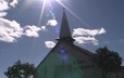
-
Innu Nikamu: live sound recorded in 1988.
11:54 min - Innu Nikamu is a Native music festival held in Mani-utenam for the last 25 years.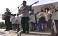
-
Innu Nikamu: Himahue concert
4:23 min - South American group Himahue at the 2003 Innu Nikamu festival.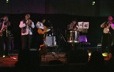
-
Innu Nikamu: Kashtin concert
8:27 min - The beginning of the internationally renowned Innu group Kashtin at Innu Nikamu, recorded in 1988.
-
Innu Nikamu: Maten concert
8:14 min - Considered to be Kashtin's successors, the Innu group Maten also hail from Mani-utenam. Recorded in 2003.
-
Innu Nikamu: Philippe Mckenzie concert
24:13 min - Philippe Mckenzie is considered to be the father of modern Innu music. Recorded in 2000.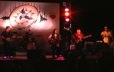
-
Innu Nikamu: Brian André concert
4:34 min - Brian André, an Innu singer from Mani-utenam, is another up-and-coming Innu singer. Recorded in 2003.
-
Innu Nikamu: Gilles Sioui concert
3:16 min - Gilles Sioui is a Huron from Wendake, an unparalleled guitarist who accompanies several aboriginal singers. Recorded in 2003.
-
Innu Nikamu: dance performance, Tshakapesh
3:18 min - The Tshakapesh dance troupe from Mani-utenam presents the Bear Dance at the 1993 festival.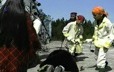
-
Innu Nikamu: concert By Eshkan
4:04 min - A group from Uashat, better known as the Grégoire brothers. Concert recorded at the festival in 1988.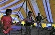
-
Innu Nikamu: concert by Guillaume Alleystock
4:22 min - Guillaume Alleystock originally hails from Barbados, but has lived with the Innu for many years. His concert was recorded at ...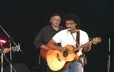
-
Innu Nikamu: concert by Sylvie Bernard
8:41 min - Sylvie Bernard is an Abenaki from Odanak. Her concert was recorded at the festival in 1988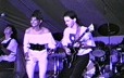
Nametau innu: Memory and knowledge of Nitassinan, a website dedicated to the Innu nation in which elders pass on their skills and knowledge to younger generations.